Research on Trigonometric Leveling
Freedu
School of Geodesy and Geomatics, Wuhan University, Wuhan 430079, China
E-mail:1111111111@qq.com
Abstract—As the total station trigonometric leveling can survey without the restrictions of topography. So, we can use it to survey the third & fourth order level survey in some special areas. In this article, we propose a new total station measuring method from combining the defect of traditional measurement methods. The advantages of this method is that it can improve the precision without measuring height of device and prism, and it can replace the third and fourth level of measurement under certain conditions. This method can greatly improve efficiency and shorten the project duration in the construction survey.
Keywords- trigonometric leveling;total station;error analysis
I. Introduction
Engineering construction often relates to height measurement. The traditional measurement methods are leveling surveying and trigonometry trigonometric leveling. Although the two methods have their own characteristics, but there are shortcomings. With the widespread use of the Total Station and using the track rod with the total station method to measure the elevation of the increasingly popular, traditional trigonometric leveling method has shown its limitations. After a long journey, a new trigonometric leveling method has been summed up. This approach combines the advantages of two traditional approaches to further improve the accuracy of the trigonometric leveling and to survey faster.
This article systematically expounds the principle of traditional trigonometric leveling methods and the new methods, compares their advantages and disadvantages, and analyses the main errors and measurement accuracy in the process of trigonometric leveling.
II. Principle of Traditional Trigonometric Leveling and the New Method
The basic formula of the traditional trigonometric leveling:
 (1)
(1)
where  is the elevation of a known point,
  is the elevation of the unknown point, D is the horizontal distance between the two points,
  is the vertical angle when observe from point A to point B,
  is instrument height, t is the height of the prism.
For traditional methods, total station must be set up in the known elevation point. At the same time, you must measure out the height of both the instrument and the prism if you want to measure the elevation of the unknown points.
If we can measure the elevation of the measured point while set point of total station arbitrarily like leveling surveying, instead of set it on a known elevation point, and do not measure out instrument and prism, speed of measurement will be faster. As shown in the figure 1, assuming that the elevation of the point A is known, the elevation of the point B is unknown, here we measure the elevation of other points by total station.
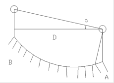
Figure 1. Diagram for trigonometric leveling
Firstly, seen by trigonometric leveling principle:
 (2)
(2)
where i, t is unknown, but one thing is sure that once the instrument set, value of i ??will remain unchanged. At the same time choose tracking lever as a reflecting prism, assume that the value of t is also fixed. Seen from formula (2),
 (3)
(3)
By formula (3), the value of W will remain unchanged in any station. And while both  and
and  are known, it is possible to calculate the value of W.
Operation of this new method is as follows:
Shown in Figure 2, elevation of point A is known, elevation of point B is unknown, and the instrument is set up at point C between A and B. The instruments sight point A to get the reading  . That
  =
=
 , and calculate the value of W, W =
  +
+ . At this time related constants such as elevation of station, instrument height and prism height can be of any value, not necessary to set before measuring.
And then set elevation of point C to W, set the instrument height and prism height to 0. Then elevation of point C is known. Finally sight the target point B and measured its elevation, that is
 (4)
(4)
Therefore, using the new method, elevation of point B is
 (5)
(5)
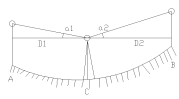
Figure 2. Diagram for the new method
In summary, with the total station set at any point, at the same time, not measuring the instrument height and prism height, we are still able to measure the elevation of the points to be measured. And theoretically, the results can have higher precision than using traditional trigonometric leveling. Because it cuts down the sources of error. It is worth to note that, while in the actual measurement, the prism height can also be changed according to the actual situation. If the change of value of t can be recorded, we can calculate the elevation of the points to be measured on the basis of measurements.
III. Accuracy Control of Trigonometric Leveling
Using the new method of trigonometric leveling do not need to measure the instrument height and prism height, thus simplifying the measurement steps, and at the same time, reducing the sources of error, improving the observation precision.
2.1 Accuracy Analysis
Known from the above, the elevation difference between the point A and the unknown elevation point B is
 (6)
(6)
Accuracy analysis below, for ease of differential, formula (6) becomes
 (7)
(7)
 ,
, are the slant range between the instrument and prisms, as shown in figure 3.
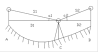
Figure 3. Accuracy analysis of new trigonometric leveling method
Total differential of formula (7):

 (8)
(8)
The first is the height difference error caused by ranging error, while the second is the height difference error caused by vertical angle error, which, D1, D2 are the foresight and the backsight. According to the variance-covariance propagation law, the formula (8) is converted into the formula of mean square error of elevation difference:
 (9)
(9)
The line of sight close to equal before and after surveying process, meanwhile, if we keep the vertical angle unchanged, then we can assume  , formula (9) can be simplified as below:
 (10)
(10)
Taking round trip measurement, mean square error of square number of height difference for one station is
 (11)
(11)
By formula of total error on leveling
 (12)
(12)
Total mean square error per kilometer
 (13)
(13)
where L is the range sum of foresight and backsight.
2.2 Accuracy Estimation
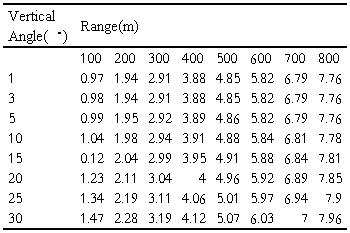
Following take total station which is frequently used in the engineering (nominal accuracy: angle ± 2 ", rang 2 mm ± 2 ppm) as an example. Estimating the accuracy of errors caused by direction and angle measurement, and accuracy of mean square error of height difference, the results are shown in Table 1, Table 2 and Table 3.
As can be seen from the above analysis and calculation in the table, the error of height difference and error caused by vertical angle measurement approximated by a linear relationship. Taking double of mean error in Table 3.3 as the limit of the height difference measurement, taking the vertical angle of less than 25 °, meanwhile, line-of-sight being no more than 700m, comparing error per kilometer height difference with the level of third-class geometric allowed:


The result can meet the requirements of the Third Order Leveling. Under certain circumstances, this new method of leveling can take the place of Three & Four Order Leveling, particularly in the hills and mountains.
TABLE I. Error Caused by Vertical Angle Measurement

TABLE II. Error Caused by Range Measurement
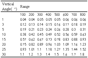
TABLE III. Mean Square Error of Height Difference
IV. Conclusion
By analysing the new method of trigonometric leveling and its error, we come to the following conclusions:
1) Using the new method of trigonometric leveling, we can set the stations at any point, without measuring instrument height and prism height, thus surveying faster.
2) The new method does not require measuring instrument and prism height, so as to reduce the sources of error and improve accuracy.
3) During observation, total station is placed in the middle. So it can effectively weaken or eliminate the curvature of the earth and atmospheric refraction, and, further improve the accuracy.
4) Using the new method of trigonometric leveling, we can set the stations at any point, and at the same time we can observe without terrain restrictions, for which it’s particularly suitable for surveying and mapping in the hilly and mountainous areas. Under certain conditions, it can take the place of Three & Four Order Leveling to improve the operating efficiency of observation.
Acknowledgment
First and foremost, I would like to show my deepest gratitude to my supervisor, Dr. Huang, who has provided me with valuable guidance in every stage of the writing of this thesis.
I shall extend my thanks to Mrs. Yin for all her kindness and help. I would also like to thank all my teachers who have helped me to develop the fundamental and essential academic competence.
Last but not least, I' d like to thank all my friends, especially my three lovely roommates, for their encouragement and support.
References
[1] Guo Z H, Zheng J F (2004) A study of formula err or on EDM trigonometric leveling. Belletin of Surveying and Mapping , (7) : 12~13.
[2] Zhou S Q (1999) The trial of replacing second order level surveying with precise triangulated height surveying. WTUSM Bulletin of Science and Technology, (3): 25~29.
[3] Pan S Q (1999) Atmospheric vertical refraction correct ionfortriangular altitude survey according to atmospheric temperature change rate. Journal of Hohai University, 27 ( 5): 12~16.
[4] Jiang C G (1996) The theoretical studies and preliminary test on accurate calculation of precise trigonometric leveling. Surveying and Mapping of Sichuan , 19( 3) : 125~128.